

In January 1943, the U.S. Army selected the town of Hanford, Washington, as the site for plutonium production on the Manhattan Project. Beginning in February 1943, the Army acquired vast amounts of land around Hanford pursuant to the Second War Powers Act. The three hundred residents of Hanford were evacuated and relocated.
The land condemned for the Manhattan Project ultimately became the Hanford Engineering Works. Although much of the land was contaminated by radiation because workers of the 1940s did not know how to manage it adequately and were more interested in winning World War II, the land has also been preserved because it has not been occupied for over sixty years now.
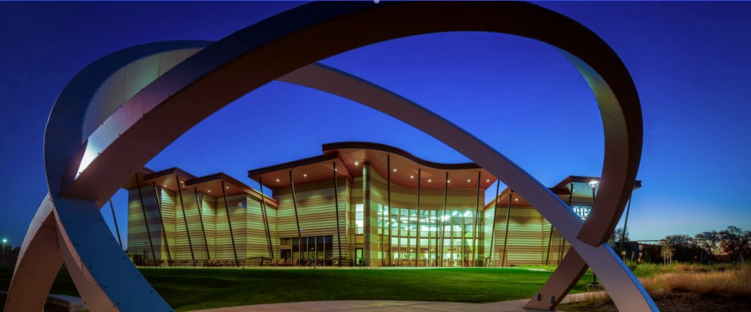
That, at least, is the premise of the Hanford Reach Interpretive Center in Richland, Washington, which I visited earlier this spring. As I’ve written before, I grew up in Richland. Although I knew a lot about the region’s history, I learned some things about my hometown and the surrounding area during my visit to the museum in April.
Hanford Reach is now a National Monument, operated by the U.S. Fish and Wildlife Service. The Monument protects the species that live along the Columbia River and preserves the history of the region. Both nature and technology are featured at the Hanford Reach Museum. Part of the museum features the wildlife and Native American history along the Columbia River. And part of it shows the development of the Hanford Engineering Works.

Several plutonium reactors sit on the Columbia’s shores from Hanford’s time as part of the World War II Manhattan Project, when Hanford developed the plutonium for the atomic bomb dropped on Nagasaki. Now, these reactors are being dismantled and the area decontaminated.
I drove past the Hanford area with my father several years ago, and he told me about the area’s significance in the development of nuclear energy. I asked why there wasn’t a museum out near the reactors.
“It’s hotter than a pancake,” he told me. And he didn’t mean the sunshine’s heat.
But without the forced depopulation of the area and the restrictions on its use for any purpose other than nuclear development during and after World War II, this region’s unique vegetation and topography could easily have been destroyed. Instead, geographic features, traditional Native American sites, and early development by white settlers have all been preserved.
And now, the National Monument and the Hanford Reach Museum educate the public on these resources and history.
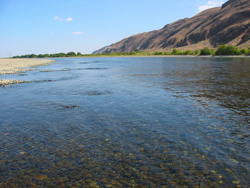
Hanford Reach is now the most natural stretch of the Columbia River, undeveloped for more than sixty years. It is the last place one can see the undammed beauty of the river—the only section of the Columbia in the United States that is not either tidal or part of a dammed reservoir. It is located where the Columbia bends northward in its generally southward course from Canada.
For hundreds of years, the Cayuse and Nez Perce tribes lived along the Columbia and Snake Rivers. They fished in the rivers, hunted in the hills, and built their nomadic culture primarily around horses and salmon.
Lewis and Clark were some of the first white explorers to pass through the region. They reached the confluence of the Columbia and Snake Rivers just south of Hanford Reach and continued on down the Columbia to its mouth. David Thompson of the Northwest Company, an early fur trader, passed through the Hanford Reach in 1811 on his way down the Columbia River.
Permanent settlement began in the 1850s, and a ferry at White Bluffs opened in 1859. The town of White Bluffs became a transportation center for both river and overland distribution from British Columbia to Montana. Gold was discovered in the area in the 1870s.
While not quite the Oregon Trail or the California Gold Rush, the Hanford region received its share of Western progress. Farming and cattle ranching weren’t far behind the transportation and mining developments.
And once the Hanford Ditch irrigation system was built in 1907, followed by the Northern Pacific Railroad in 1913, the areas around White Bluffs, Hanford, and Wahluke all prospered until the Great Depression.
I’ll discuss the development of the Hanford Engineering Works in a later post. In the meantime, I hope you are as impressed as I am with the history behind what appears to be a desert. And let’s not forget the accidental preservation of the area because of WWII and its aftermath.
What do you know of the history of the area where you grew up?
Discover more from Theresa Hupp Author
Subscribe to get the latest posts sent to your email.


Yes. Fort Scott, KS was the end of civilization in1842. The fort is restored and open for visitors.
“It’s hotter than a pancake.” I love that, Theresa. I grew up outside of Washington, DC. On of my favorite places was Mount Vernon.
Hi Theresa, This is great information. I grew up in the Northwest and traveled all over Oregon and Washington as a photographer and I have never heard of the Hanford Reach. I will have to check out the Interpretive center in Richmond next time I am up that way. Thanks for sharing.
Thanks for the comment. The museum is worth a stop. Someday I’d like to tour the actual Reach.
Theresa
[…] I wrote a couple of months ago about how the Manhattan Project preserved the natural beauty of the Columbia Reach in eastern Washington. In addition to preserving this unique part of our nation’s landscape, the Manhattan Project also enhanced the development of my home town of Richland, Washington. […]